Scene 1 (0s)
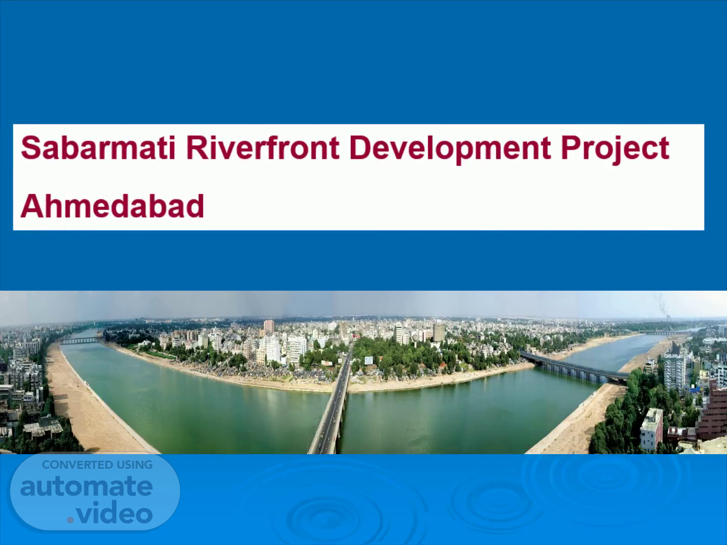
Sabarmati Riverfront Development Project Ahmedabad.
Scene 2 (6s)
sabarmati_05. sabarmati_04.
Scene 3 (12s)
sabarmati_05.
Scene 4 (18s)
Existing Situation. Unauthorized encroachment on river bank. Unauthorized dumping of domestic / industrial waste. Improper access to river by citizen. Shabby and dirty look river. Average river width is varying from 296 to 732 mts. Height of bank ranging from 4 to 12.50 mts. General slope of the river is 1:5000. The edge of the river is not clearly defined by embankment / retaining wall..
Scene 5 (38s)
Project Objectives. Keep River clean through diversion of sewers Reconnect city to the river Create conducive urban environment Create urban space for public utilities like parks, garden, jogging track, walkway, informal market etc..
Scene 6 (52s)
Key aspects of the Project. Overall environmental improvement Creating high quality public open spaces Providing adequate public access to the river Rehabilitating the slums Creating vibrant urban neighborhoods Providing city level infrastructure.
Scene 7 (1m 4s)
SPV to Execute Sabarmati River Front Development.
Scene 8 (1m 22s)
Project Details. Total Length 21 Kms i.e., 42 Kms considering East and west side Phase -1 is 12.5 Kms and Phase – 2 is 8.5 Kms Phase – 1 in 3 stages i.e., Stage 1, Stage 2 and Stage 3 Stage 1 is completed, stage 2 is under progress and Stage 3 is also under progress Project site of 455 ha is located on the both the sides of Sabarmati river bank Approximate 21 km stretch passing through the heart of the city of Ahmedabad.
Scene 9 (1m 45s)
Detailed survey of the physical features of the river, bridges and adjacent areas. Analysis of river hydraulics Study of existing land use for the use of reclaimed land. Study of various options for retaining wall and embankment. Comprehensive survey and analysis of river bank slums. Detailed survey of storm water outfalls and options for preventing the discharge of sewage into the river. Land ownership.
Scene 10 (2m 5s)
Detailed survey of the physical features. Cross section of the riverbed at every 100 m interval. Longitudinal sections of the riverbed at every 30 m interval along the cross section line. Physical features of all bridges. Alignment, pier position, RL of bridge tops. Vasna Barrage : RL of top of the walkway and spillway. Gate positions Location of storm water outlets along both the banks with size and invert levels. Detailed survey of adjoining areas..
Scene 11 (2m 27s)
Analysis of river hydraulics. The objective of the river hydraulic study was to ensure for: Narrowing of the water way does not in any way rise the HFL beyond expected in the natural condition. Construction of retaining wall and embankment Scouring of riverbed Analysis for stability of existing bridges.
Scene 12 (2m 43s)
Land use of reclaimed land.. Commercial Development Residential Development Parks / Gardens / Urban Forest Roads and Promenades Informal Markets Housing for Slum relocation Recreational Development Heritage park Public Utilities.
Scene 13 (2m 55s)
Proposed Land Use. Proposed Land use Area (Ha) % Roads 129.90 28.53 Gardens 119.70 26.29 Promenades 27.40 6.02 Commercial Areas 62.00 13.61 Residential Areas 34.90 7.66 Relocation Sites 43.30 9.50 Informal Markets 16.40 3.60 Public Utilities 2.10 0.47 Extension of Public Facilities 2.60 0.58 Residual/Un allocated 17.00 3.74 Total 455.30 100.
Scene 14 (3m 19s)
Survey and analysis of river bank slums. Data collected with other information for the slum located on; On the riverbed Slope of the riverbed and on the adjacent land On the adjacent land Project affected economic activities: Laundering Informal markets Sand collection Cultivation (during dry season) Dyeing.
Scene 15 (3m 34s)
Storm water outfalls and options for preventing the discharge of sewage into the river.
Scene 16 (3m 55s)
Land Ownership. Gujarat State Government was approached to vests the reclaimed land to AMC for SRFD Project purpose. The Government has transferred the land other than the land to be used for commercial purpose to AMC for SRFDCL at token rate. The commercial land to be transferred at the 50% rate as decided by the district valuation committee..
Scene 17 (4m 13s)
LAND VALUE. Out of total requirement of 455 ha of land, 161.79 ha of land transferred by GoG for Phase 1 of the project. GoG decided to transfer 32.68 ha for Dev. of Commercial and Residential at 50% of market value (Rs. 19 crores) and balance 130.11 ha at token price (Rs. 1 only) Present value of market rate is Rs. 50000/- as per AMC and accordingly the valuation is Rs 1634 Crores..
Scene 18 (4m 36s)
Financing of the PROJECT. Estimated Cost Phase-1= Rs. 1147 cr. (under construction) Equity of AMC = Rs. 247 cr. Loan from HUDCO = Rs. 900 cr. Rs. 200 Cr. already released, Rs.350 Cr. under sanction and Rs.350 Cr in Pipeline Loan tenure 15 yr including repayment Loan servicing by AMC / SRFDCL Source of Revenue: 20% of the reclaimed land to be allotted for commercial development.
Scene 19 (4m 57s)
1. Diaphragm Wall and Anchor Slab (Lower Level) 2. Diversion Drains and Outfall Extensions 3. Retaining wall (Upper Level) 4. Relocation of Slums Dwellers & Structures 5. Establishment of Boundary 6. General Fill 7. Access Roads 8. Infrastructure (Roads, Water supply, Sewerage, Storm water) 9. Development Rights/ Sale of Land 10. Development of Public Buildings, Gardens & Amenities 11. Construction of Buildings by Private Firms.
Scene 20 (5m 19s)
00. 0. Original Condition. Stages of Construction.
Scene 21 (5m 27s)
01. Diaphragm Wall and Anchor Slab (Lower Level).
Scene 22 (5m 34s)
DSC_4694. View of Lower Level Work Platform Site preparation.
Scene 23 (5m 41s)
DSC_4696. View of Guide Wall – Construction.
Scene 24 (5m 48s)
DSC04548. View of Guide Wall –Construction.
Scene 25 (5m 55s)
DSC08044. View of Diaphragm Wall –Construction.
Scene 26 (6m 2s)
View of Anchor Slab – Construction.
Scene 27 (6m 9s)
DSC00075. View of Lower Level Promenade - Nehru Bridge West Upstream.
Scene 28 (6m 16s)
DSC00674. Subhash Bridge to Gandhi Bridge (West).
Scene 29 (6m 23s)
West Bank. Picture 084. Gandhi Bridge to Sardar Bridge (West).
Scene 30 (6m 31s)
Picture 054. West Bank.
Scene 31 (6m 37s)
DSC00077. View of Lower Level Promenade - Nehru Bridge East Downstream.
Scene 32 (6m 45s)
Picture 057.
Scene 33 (6m 51s)
vill -. View of Lower Level Promenade - Hotel Patang (West).
Scene 34 (7m 1s)
DSC00006. View of Diversion Drains – Under Construction.
Scene 35 (7m 8s)
100_2855. View of Diversion Drains – Subhash Bridge East Downstream.
Scene 36 (7m 15s)
100_6727.
Scene 37 (7m 21s)
DSC08037. View of Diversion Drains – Sardar Bridge East Downstream.
Scene 38 (7m 28s)
03. Retaining wall (Upper Level). Stages of Construction.
Scene 39 (7m 35s)
Picture 081. Retaining Wall Under Construction – Gandhi Bridge West Upstream.
Scene 40 (7m 43s)
100_6479.
Scene 41 (7m 49s)
100_6485.
Scene 42 (7m 54s)
100_6487.
Scene 43 (8m 0s)
100_6512.
Scene 44 (8m 5s)
100_6515.
Scene 45 (8m 11s)
100_6516.
Scene 46 (8m 17s)
Picture 090. Retaining Wall Under Construction – Gandhi Bridge East Downstream.
Scene 47 (8m 24s)
100_6833. Retaining Wall Under Construction – Gandhi Bridge West Upstream.
Scene 48 (8m 32s)
100_6836. Retaining Wall Under Construction – Gandhi Bridge East Upstream.
Scene 49 (8m 39s)
100_6749.
Scene 50 (8m 45s)
100_6770.