Scene 1 (0s)
[Audio] Good morning Sir, good morning classmates. I am Gerard, and my report today is about Hurricane. Profile of A Hurricane, Hurricane Formation And Decay, Hurricane Destruction, Estimating The Intensity Of A Hurricane, and Detecting And Tracking Hurricanes..
Scene 2 (19s)
[Audio] When we say hurricane it means it is a tropical cyclone with sustained one-minute winds of at least 74 mph ( 64 knots), at an elevation of 10 meters. Derived from the Spanish word " huracan" , which was most likely inspired by Hunraken, the name for the ancient Mayan storm god or Hurakan, the Quiche god of thunder..
Scene 3 (43s)
[Audio] Hurricane has exciting facts, such as: They are tropical cyclones (low pressure areas) with sustained winds at least 64 knots ( 74 mph). Strongest hurricane on record ( Camille) had winds exceeding 200 mph. Typically 500- 1000 km in diameter (smaller than midlatitude cyclones). Can be associated with heavy rains ( 10- 20 inches!), tornadoes, and storm surges on the coast. Also called typhoons and tropical cyclones.
Scene 4 (1m 22s)
[Audio] The graph illustration below shows the disasters from 1980 to 2008. As you can see, the eastern part of the US are heavily hit by the hurricanes claiming several billions of dollars comparing to the west..
Scene 5 (1m 38s)
[Audio] Hurricane Katrina was a large and destructive Category 5 Atlantic hurricane that caused over 1,800 fatalities and $ 125 billion in damage in late August 2005, especially in the city of New Orleans and the surrounding areas. It was at the time the costliest tropical cyclone on record and is now tied with 2017's Hurricane Harvey. The storm was the twelfth tropical cyclone, the fifth hurricane, and the third major hurricane of the 2005 Atlantic hurricane season, as well as the fourth-most intense Atlantic hurricane on record to make landfall in the contiguous United States..
Scene 6 (2m 19s)
[Audio] Flooding, caused largely as a result of fatal engineering flaws in the flood protection system levees around the city of New Orleans, precipitated most of the loss of lives. Eventually, 80% of the city, as well as large tracts of neighboring parishes, were inundated for weeks. The flooding also destroyed most of New Orleans's transportation and communication facilities, leaving tens of thousands of people who had not evacuated the city prior to landfall stranded with little access to food, shelter, or other basic necessities. The scale of the disaster in New Orleans provoked massive national and international response efforts; federal, local, and private rescue operations evacuated displaced persons out of the city over the following weeks..
Scene 7 (3m 8s)
[Audio] Figure 11.24 shows the Flood waters inundate New Orleans, Louisiana, during August, 2005, after the winds and storm surge from Hurricane Katrina caused several levee breaks..
Scene 8 (3m 22s)
[Audio] The 1900 Galveston hurricane, also known as the Great Galveston hurricane and the Galveston Flood, and known regionally as the Great Storm of 1900 or the 1900 Storm, was the deadliest natural disaster in United States history and the fifth-deadliest Atlantic hurricane, only behind Hurricane Mitch overall. With approximately 8000 people died..
Scene 9 (3m 47s)
[Audio] Most of these deaths occurred in and near Galveston, Texas, after the storm surge inundated the coastline with 8 to 12 ft ( 2.4 to 3.7 m) of water. In addition to the number killed, the storm destroyed about 7,000 buildings of all uses in Galveston, which included 3,636 demolished homes; every dwelling in the city suffered some degree of damage. The hurricane left approximately 10,000 people in the city homeless, out of a total population of fewer than 38,000. The disaster ended the Golden Era of Galveston, as the hurricane alarmed potential investors, who turned to Houston instead. In response to the storm, three engineers designed and oversaw plans to raise the Gulf of Mexico shoreline of Galveston Island by 17 ft ( 5.2 m) and erect a 10 mi ( 16 km) seawall..
Scene 10 (4m 46s)
[Audio] Typhoon Haiyan, known in the Philippines as Super Typhoon Yolanda, was one of the most powerful tropical cyclones ever recorded. On making landfall, Haiyan devastated portions of Southeast Asia, particularly the Philippines. It is one of the deadliest Philippine typhoons on record, killing at least 6,300 people in that country alone..
Scene 11 (5m 12s)
[Audio] In terms of JTWC-estimated 1-minute sustained winds, Haiyan is tied with Meranti in 2016 for being the second strongest landfalling tropical cyclone on record only behind Goni of 2020. In January 2014, bodies were still being found. Haiyan was also the most intense tropical cyclone worldwide in 2013. This typhoon is also the second deadliest typhoon in the Philippines..
Scene 12 (5m 43s)
[Audio] Typhoon Haiyan, called Yolanda in the Philippines, caused catastrophic damage throughout much of the islands of Leyte, where cities and towns were largely destroyed. By April 17, 2016, the National Disaster Risk Reduction and Management Council ( NDRRMC) confirmed 6,300 fatalities across the country, 5,902 of those taking place in the Eastern Visayas. However, the true death toll remains unclear..
Scene 13 (6m 15s)
[Audio] Figure shows the Regions where tropical storms form (the red shading), the names given to storms, and the typical paths they take (the red arrows)..
Scene 14 (6m 26s)
[Audio] The Saffir-Simpson Hurricane Wind Scale is a 1 to 5 rating based on a hurricane's sustained wind speed. This scale estimates potential property damage. Hurricanes reaching Category 3 and higher are considered major hurricanes because of their potential for significant loss of life and damage. Category 1 and 2 storms are still dangerous, however, and require preventative measures. In the western North Pacific, the term "super typhoon" is used for tropical cyclones with sustained winds exceeding 150 mph. Note that all winds are using the U.S. 1-minute average. Category One Hurricane Winds 74-95 mph ( 64- 82 kt or 119- 153 km/hr). Very dangerous winds will produce some damage: Well-constructed frame homes could have damage to roof, shingles, vinyl siding and gutters. Large branches of trees will snap and shallowly rooted trees may be toppled. Extensive damage to power lines and poles likely will result in power outages that could last a few to several days. Category Two Hurricane Winds 96- 110 mph ( 83- 95 kt or 154- 177 km/hr). Extremely dangerous winds will cause extensive damage: Well-constructed frame homes could sustain major roof and siding damage. Many shallowly rooted trees will be snapped or uprooted and block numerous roads. Near-total power loss is expected with outages that could last from several days to weeks. Category Three Hurricane Winds 111- 129 mph (96- 112 kt or 178- 208 km/hr). Devastating damage will occur: Well-built framed homes may incur major damage or removal of roof decking and gable ends. Many trees will be snapped or uprooted, blocking numerous roads. Electricity and water will be unavailable for several days to weeks after the storm passes. Category Four Hurricane Winds 130- 156 mph ( 113- 136 kt or 209- 251 km/hr). Catastrophic damage will occur: Well-built framed homes can sustain severe damage with loss of most of the roof structure and/or some exterior walls. Most trees will be snapped or uprooted and power poles downed. Fallen trees and power poles will isolate residential areas. Power outages will last weeks to possibly months. Category Five Hurricane Winds 157 mph or higher ( 137 kt or higher or 252 km/hr or higher). Catastrophic damage will occur: A high percentage of framed homes will be destroyed, with total roof failure and wall collapse. Fallen trees and power poles will isolate residential areas. Power outages will last for weeks to possibly months. Most of the area will be uninhabitable for weeks or months..
Scene 15 (9m 56s)
[Audio] Figure shows The number of hurricanes (by each category) that made landfall along the coastline of the United States from 1900 through 2005. All of the hurricanes struck the Gulf or Atlantic coasts. Categories 3, 4, and 5 are considered major hurricanes..
Scene 16 (10m 16s)
[Audio] You may click the link to watch the videos..
Scene 17 (10m 30s)
[Audio] Figure shows the total number of hurricanes and tropical storms (red shade) and hurricanes only (yellow shade) that have formed during the past 100 years in the Atlantic Basin—the Atlantic Ocean, the Caribbean Sea, and the Gulf of Mexico..
Scene 18 (10m 46s)
[Audio] At this moment, we will proceed to the Hurricane structure..
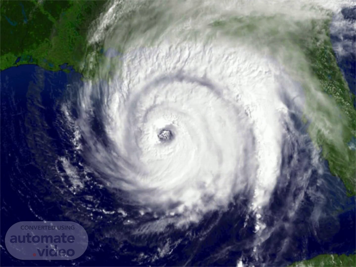
Scene 19 (10m 52s)
[Audio] The figure shows the Visible satellite image of Hurricane Ivan as it makes landfall near Gulf Shores, Alabama, on September 15, 2004. Ivan is a major hurricane with winds of 105 knots ( 121 mi/hr) and a surface air pressure of 945 mb ( 27.91 in)..
Scene 20 (11m 16s)
[Audio] Contrary to how many weather maps appear, a hurricane is more than a point on a weather map, and its path is more than a line. It is a large system that can affect a wide area, requiring that precautions be taken far from where the eye is predicted to come ashore. This section talks about the different parts of the hurricane and will help you better understand hurricane hazards..
Scene 21 (11m 39s)
[Audio] This is the infrared satellite video of a hurricane taken from an advance weather satellite located at the Atlantic..
Scene 22 (11m 48s)
[Audio] The figure shows the Color radar image of Hurricane Andrew as it moves on shore over south Florida on the morning of August 24, 1992. The National Hurricane Center ( NHC) is located about 30 km ( 19 mi) from the center of the eye..
Scene 23 (12m 7s)
[Audio] The main parts of a hurricane are the rainbands on its outer edges, the eye, and the eyewall. Air spirals in toward the center in a counter-clockwise pattern, and out the top in the opposite direction. In the very center of the storm, air sinks, forming the cloud-free eye. The Eye is the hurricane's center is a relatively calm, clear area usually 20- 40 miles across. People in the midst of a hurricane are often amazed at how the incredibly fierce winds and rain can suddenly stop and the sky clear when the eye comes over them. Then, just as quickly, the winds and rain begin again, but this time from the opposite direction. The Eyewall is the dense wall of thunderstorms surrounding the eye has the strongest winds within the storm. Changes in the structure of the eye and eyewall can cause changes in the wind speed, which is an indicator of the storm's intensity. The Spiral Rainbands is the storm's outer rainbands (often with hurricane or tropical storm-force winds) can extend a few hundred miles from the center. Hurricane Andrew's in 1992, rainbands reached only 100 miles out from the eye. These dense bands of thunderstorms, which spiral slowly counterclockwise, range in width from a few miles to tens of miles and are 50 to 300 miles long. Sometimes the bands and the eye are obscured by higher level clouds, making it difficult for forecasters to use satellite imagery to monitor the storm..
Scene 24 (13m 44s)
[Audio] The top diagram shows an intensifying tropical cyclone. As latent heat is released inside the clouds, the warming of the air aloft creates an area of high pressure, which induces air to move outward, away from the high. The warming of the air lowers the air density, which in turn lowers the surface air pressure. As surface winds rush in toward the surface low, they extract sensible heat, latent heat, and moisture from the warm ocean. As the warm, moist air flows in toward the center of the storm, it is swept upward into the clouds of the eyewall. As warming continues, surface pressure lowers even more, the storm intensifies, and the winds blow even faster. This situation increases the transfer of heat and moisture from the ocean surface. The middle diagram illustrates how the air pressure drops rapidly as you approach the eye of the storm. The lower diagram shows how surface winds normally reach maximum strength in the region of the eyewall..
Scene 25 (14m 52s)
[Audio] The eye of the hurricane slopes outward as shown in the photo..
Scene 26 (14m 59s)
[Audio] In much the same way an ice skater spins more quickly as her arms are tucked close into her body, a hurricane also spins at a faster pace near the center than near the outer edge..
Scene 27 (15m 12s)
[Audio] The destruction is most intense on right side of cyclone because it is the sum of wind and storm speed..
Scene 28 (15m 20s)
[Audio] A shrinking eye indicates storm intensification. Some intense hurricanes develop double eye walls, as rain bands contract and intensify. Eye wall replacement leads to weakening of the hurricane winds, followed by renewed strengthening..
Scene 29 (15m 39s)
[Audio] Secondary eyewalls were once considered a rare phenomenon. Since the advent of reconnaissance airplanes and microwave satellite data, it has been observed that over half of all major tropical cyclones develop at least one secondary eyewall. Qualitatively identifying secondary eyewalls is easy for a hurricane analyst to do. It involves looking at satellite or radar imagery and seeing if there are two concentric rings of enhanced convection. The outer eyewall is generally almost circular and concentric with the inner eyewall. Quantitative analysis is more difficult since there exists no objective definition of what a secondary eyewall is. Kossin et al.. specified that the outer ring had to be visibly separated from the inner eye with at least 75% closed with a moat region clear of clouds..
Scene 30 (16m 36s)
[Audio] It is so true that the Greatest Damage and Loss of Life from Hurricanes is Near the Coast Associated with Storm Surges after we experienced Typhoon Yolanda in the Philippines..
Scene 31 (16m 48s)
[Audio] Along the coast, storm surge is often the greatest threat to life and property from a hurricane. In the past, large death tolls have resulted from the rise of the ocean associated with many of the major hurricanes that have made landfall. Typhoon Haiyan or Yolanda is a prime example of the damage and devastation that can be caused by surge. At least 5600 persons lost their lives during Yolanda and many of those deaths occurred directly, or indirectly, as a result of storm surge..
Scene 32 (17m 22s)
[Audio] Storm surge is an abnormal rise of water generated by a storm, over and above the predicted astronomical tides. Storm surge should not be confused with storm tide, which is defined as the water level rise due to the combination of storm surge and the astronomical tide. This rise in water level can cause extreme flooding in coastal areas particularly when storm surge coincides with normal high tide, resulting in storm tides reaching up to 20 feet or more in some cases. Storm surge is produced by water being pushed toward the shore by the force of the winds moving cyclonically around the storm. The impact on surge of the low pressure associated with intense storms is minimal in comparison to the water being forced toward the shore by the wind..
Scene 33 (18m 13s)
[Audio] The diagram shows the changing of the ocean level as different category hurricanes make landfall along the coast. Notice that the water typically rises about 4 feet with a Category 1 hurricane, but may rise to 22 feet (or more) with a Category 5 storm..
Scene 34 (18m 32s)
[Audio] The photos shows the Beach homes along the Gulf coast at Orange Beach, Alabama (a) before, and (b) after Hurricane Ivan made landfall during September, 2004. ( Red arrows are for reference.).
Scene 35 (18m 48s)
[Audio] The maximum potential storm surge for a particular location depends on a number of different factors. Storm surge is a very complex phenomenon because it is sensitive to the slightest changes in storm intensity, forward speed, size ( radius of maximum winds- RMW), angle of approach to the coast, central pressure (minimal contribution in comparison to the wind), and the shape and characteristics of coastal features such as bays and estuaries..
Scene 36 (19m 18s)
[Audio] These are some of the video links we can watch from YouTube as reference for storm surge. Storm surges in the Philippines is not a common term that mostly people didn't realize its disastrous effects. Therefore, education and information dissemination is vital during the calamities so that people are equipped and will be prepared..
Scene 37 (19m 41s)
[Audio] What is the energy source of Hurricanes? A vital question to understand the nature of the hurricane..
Scene 38 (19m 50s)
[Audio] Hurricanes get their energy from the warm, waters of the tropics. Require the water surface to be at least 80F. Also need moist air through depth and weak wind shear. Generally develop as a weak tropical disturbance moves over the oceans..
Scene 39 (20m 9s)
[Audio] CISK stands for Convective Instability of the Second Kind. Not only does a changing temperature profile lead to more or less instability. Instability is also influenced by the moisture profile. Instability will increase further when the dewpoint near the surface increases. The addition of moisture makes the air less dense near the surface but more importantly releases more latent heat when air rises and condenses into precipitation. Air that is less dense and is warmer due to latent heat release will produce a more significant convection. Severe thunderstorms often have an environment with warm and humid air near the surface with cool air aloft. The wind-induced surface heat exchange ( WISHE) is a positive feedback mechanism between the ocean and atmosphere in which a stronger ocean-to-atmosphere heat flux results in a stronger atmospheric circulation, which results in a strong heat flux. It has been hypothesized that this is the mechanism by which low pressure areas in the tropics develop into tropical cyclones..
Scene 40 (21m 19s)
[Audio] We generally associate tropical cyclones with the damage they do when they come in contact with land, but they spend most of their " life" out in the ocean and are a phenomenon best explained in terms of heat transfer between the atmosphere and the ocean. Tropical cyclones are storms that are born in tropical oceans and depend on warm water for their source of energy. They originate between 4° and 22° S of the equator, and between 4° and 35° N of the equator. During the northern hemisphere's summer (July-September), most of the energy is delivered to the sub-tropical region of the northern hemisphere. The result is the development of large cyclonic (counterclockwise rotating) cells that are termed hurricanes if they form near North America and typhoons if they are formed in the western Pacific. Tropical cyclones do not, however, occur in the equatorial zone. More than two-thirds of tropical cyclones occur in the northern hemisphere and occur between May and November, when the ocean is at its warmest, with a peak in August and September. In the southern hemisphere, they occur between December and April, with peaks in January and February, where they are typically called cyclones..
Scene 41 (22m 38s)
[Audio] Many Atlantic Hurricanes Begin as Tropical Waves Over Africa while Tropical Storms begin in the Pacific Ocean..
Scene 42 (22m 47s)
[Audio] The generation of a tropical cyclone is dependent upon the transfer of thermal energy from the ocean to the atmosphere. When significant volumes of warm water vapor move upwards, low-pressure cells develop at the Earth's surface and large storms are generated. In the process, water vapor evaporated into the atmosphere will cool and condense..
Scene 43 (23m 12s)
[Audio] This is ultimately how storm clouds are produced. As the water begins to fall back to the surface, large scale convective cells are generated, and the air mass is forced to spin in response to the Coriolis Effect. This causes deflection of air masses to the right in the northern hemisphere and deflection to the left in the southern. For storms to sustain themselves, the upward movement of warm water vapor needs to be constantly resupplied or the storm will weaken and eventually fall apart..
Scene 44 (23m 45s)
[Audio] For a tropical cyclone to generate, the temperature of the upper 60 meters (~ 200 ft.) of the ocean water must be greater than 26°C (~ 79°F). In addition, certain atmospheric conditions are needed to drive the formation of convection cell described above. Horizontal shear winds prevent formation; conversely, in conditions with low wind shear, heat and moisture are retained to allow continued development. The building of the tall cumulonimbus clouds associated with a tropical cyclone depends on the deep convection currents extending into the troposphere. The initial anomaly is called a tropical wave, and then with progressive intensification, it is called a disturbance, an investigation (where it is given a number), then a depression, tropical storm, then a hurricane..
Scene 45 (24m 42s)
[Audio] During the past thirty years there has been a substantial improvement in hurricane track forecasts as computer models improved and more data became available to describe their environment. Over the same period only minimal improvement is hurricane intensity forecasts..
Scene 46 (25m 0s)
[Audio] Hurricane movement is guided by surface winds. As we will see in the examples given, the Atlantic hurricanes travel west or northwest across the Atlantic and then recurve to the north and then northeast. This curvature is dictated by the Coriolis effect, which is caused by the Earth's rotation. This pattern also occurs in the northern Pacific. Although these are predictable patterns, each storm has a unique path and there is great variation depending upon the atmospheric conditions near the storm, which act as steering forces..
Scene 47 (25m 35s)
[Audio] As we will see later wind movements are a function of atmospheric pressure, with storms basically moving around high pressure systems and towards low pressure systems. Nevertheless, the patterns made by the historic tracks seen in the animation below show how the storms generally follow certain rules. This predictability aids in forecasting the paths using satellite data and numerical modeling..
Scene 48 (26m 2s)
[Audio] The diagram shows the movement of the typhoon Katrina..
Scene 49 (26m 12s)
[Audio] The diagram shows the Official Annual Average Intensity Errors Atlantic basin tropical Cyclonce..
Scene 50 (26m 20s)
[Audio] When it comes to hurricane forecasting, NOAA has many tools. Radar, satellites and computer models all play a role in forecasting hurricanes, but they each have their own limitations. In order to overcome these limitations, NOAA operates two Lockheed WP- 3D Orion aircraft in order to conduct low-altitude data collection to fill gaps in data not available from ground based radar or satellite imagery. NOAA's WP-3D Orions are equipped with a unique array of scientific instrumentation, radars and recording systems for measurements of the atmosphere, the earth and its environment. Obtained as new aircraft from the Lockheed production line in the mid- 70s, these robust and well maintained aircraft have led NOAA's continuing efforts to monitor and study hurricanes and other severe storms, the quality of the atmosphere, oceanographic conditions, and climate trends..